Hope Valley
OS Grid ref:-
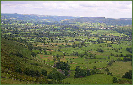 The Hope Valley is situated in the Peak District National Park. The large, wide valley runs East-West along the boundary between the gritstone moors and edges of the Dark Peak and the limestone outcrops and dales of the White Peak.
The popular village of Castleton, which is a tourist magnet in the summer months, has a number of tourist attractions. There are many pubs, guest houses and tea shops. The village has a large visitor's car park, a variety of gift shops and a youth hostel. Castleton also has an interesting information centre with audio-visual displays. The main centre for visitors exploring the Hope Valley, it houses the Castleton Village Museum and many local treasures, some dating from prehistoric times. Visitors are inspired to discover the delights of Castleton and the Hope Valley through interactive and interpretative displays.
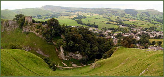
 Peveril Castle (pictured below right) stands imposingly on a limestone outcrop guarding the village and dominates the surrounding landscape. The castle (pictured below right) was founded by William Peverel (c. 1040circa. 1115) a Norman knight, who was granted extensive lands in Derbyshire and Nottinghamshire by King William I in reward for supporting him during the Norman Conquest of England.
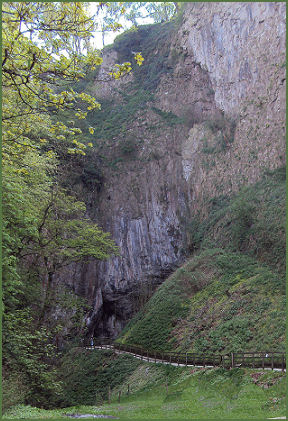
The Peak Cavern, (pictured right) also known as the Devil's Arse, is a large show cave in the village. Unlike the other show caves in the Castleton area, Peak Cavern is almost entirely natural, the only artificial part of the cave was blasted through to bypass a low tunnel which was only accessible by lying down on a boat. The cave is the largest in the Peak District, and its main entrance, measuring 102 feet wide and 60 feet in height, is the largest cave entrance in Britain.
The village of Hope is recorded in the Domesday Book of 1086. Medieval St. Peter's Church at Hope dates back to around the thirteenth century and has a Norman font, a carved oak pulpit dated 1652 and a schoolmasters chair from the same period. In the churchyard stands a fine Anglo-Saxon cross. Hope also boasts a market cross dating from the medieval period which stands on a base of six octagonal steps.
The remains of a Roman fort built to oversee lead mining in the area, can be found in the hamlet of Brough-on-Noe, just east of the village of Hope. The Romans knew it as Navio, and was later renamed with the Old English word for fort, brough.
 The distinctive, dome-shaped Mam Tor, near the summit of the limestone gorge of Winnat's Pass, rising to a height of 517 metres (1,696 feet) stands at the head of the valley. At the base of the Tor and nearby are a number of caves: Blue John Cavern, Speedwell Cavern, and Treak Cliff Cavern where lead, Blue John, fluorspar and other minerals were once mined.
At Winnat's Pass, the road winds steeply through a ravine, rising up from the Hope Valley to the south of Mam Tor and is surrounded by dramatic towering limestone pinnacles. The pass was once thought to have originated as a giant collapsed cavern, however, a more recent explanation is that it was a ravine between the coral reefs that originally formed the limestone. A walk from Mam Tor to Losehill along the ridge which divides the Hope and Edale valleys gives stunning views in both directions.
Legend states that a Dark Age battle took place at Lose Hill in the mid seventh century between the allies Penda, King of Mercia and Cynegils of Wessex and King Edwin of Northumbria, hence the names of and Lose Hill and nearby Win Hill (where Edwin, the victor's forces were said to have been stationed). The battle was long and fierce, any by the end the river Noe, which flows between the two hills, is reported to have ran red with blood.
At the opposite end of the valley Stanage Edge, on the edge of the Eastern Moors near Hathersage, looms on the horizon. The stunning view from the gritstone escarpment is one of the most spectacular in the Peak District. Once a private grouse moor, it is now a highly popuar location with climbers and walkers, and has good footpaths beneath it and a path along its edge. There are over 500 climbing routes on the Edge. The highest point on Stanage Edge is High Neb which rises to 458 metres (1,503 feet). The edge runs for four miles from the Cowper Stone at the south to Stanage End.