Stanage Edge
OS Grid ref:- SK228853
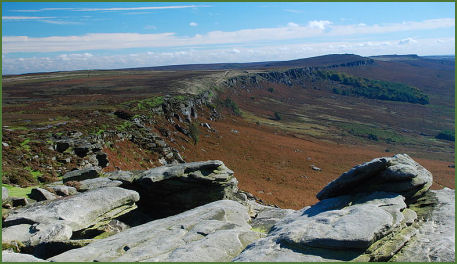 The stunning view from the gritstone escarpment of Stanage Edge, on the edge of the Eastern Moors near Hathersage, is one of the most spectacular in the Peak District, extending across the Hope Valley, the Upper Derwent Valley, and towards Chatsworth House which lies to the south, the view to the north takes in dramatic Kinder Scout and Win Hill.
Stanage Edge is the largest of the gritstone edges in the Peak District National Park and was formed during the last Ice Age, some 10,000 years ago. Once a private grouse moor, it is now a highly popuar location with climbers and walkers, and has good footpaths beneath it and a path along its edge. There are over 500 climbing routes on Stanage Edge, where one sheer gritstone face is named "The Unconquerable".
The highest point on Stanage Edge is High Neb which rises to 458 metres (1,503 feet). The edge runs for four miles from the Cowper Stone at the south to Stanage End, many of the Edges acquire their names from the villages which lie in their shadow, such as Baslow Edge, Froggatt Edge and Curbar Edge. The rock face itself reaches a maximum height of 25 metres, but for most of its length it is between 15 and 20 metres in height.
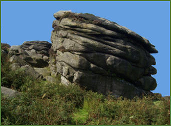 The Cowper Stone (pictured right) is a block of gritstone at the most southerly point of the Edge, standing solitary a few hundred metres from the last buttress of the main crag, it is a large boulder with distinctive rounded breaks running across it. The small cave and ledge at the upper section of the escarpment is known as Robin Hood's Cave, where legend states the outlaw was said to have used as a hideaway.
The remains of a paved packhorse road which once ran along the top of the edge is still visible, as are the remains of the Long Causeway Roman road which crosses the edge on its route from Templeborough to Brough-on-Noe, crossing Hallam Moor and passing the ancient waymarker known as Stanedge Pole. The tall wooden pole has been replaced many times over the centuries, but its supporting rock base is carved with the date 1550.
In recent years film producers have chosen the edge for the setting of the 2005 film adaptation of Pride and Prejudice starring Keira Knightley, as well as the 2006 BBC production of Jane Eyre.
The name Stanage Edge derives from "stone edge". Car Parks are provided at Hollins Bank & Picnic area (OS grid ref- SK237837) Hooks Car (SK246829) and Dennis Knoll (SK228843).
Image 1 courtesy of Rob Bendall
A walk on Stanage Edge
Distance about 7 miles
*Commencing at at Hathersage Railway Station, turn left and after a short distance, join another road which descends to the village main street. Turn right, then left onto Baulk Lane.
*Follow the lane to reach a signpost, bearing left across a field towards the back of Brookfield Manor. Continue up to the road and turn right then turn left up the tarmac road which leads uphill to North Lees Hall. After passing the hall, turn right onto the path which leads across a field. Pass through the gate at the other side of the field andcontinue along the wooded path, bear left to ascend steps to a road and the ranger station.
*Cross the road and follow the path directly opposite to reach the crest of the edge. Turn right along the edge and continue along the ridge to reach the trigpoint on Cowper Stone. Continue along the track as it veers to the left, descending across moorland to the road and car park at Upper Burbage Bridge.
*Cross the bridge and turn right along the path below Burbage Rocks. Continue along this path until arriving at a crossing, at which point ake the right hand path. Continue along this path, crossing two footbridges, to ascend to Carl Wark, then continue to Higger Tor. From the summit of the tor, follow the path which bears left towards the road. Cross the road and continue onto the moorland.
*Turn left following the footpath which descends sharply down Callow Bank. This leads onto a further track to a gate onto Mitchell Field conservation area, continue to follow the footpath through the conservation area and across the fields and woodland paths to reach the road. Turn right and follow the road to return to Hathersage.