Wildboarclough
OS Grid ref:- SJ983688
The Peak District village of Wildboarclough (pronounced Will'berclough) nestles in an upland valley in a superb scenic location to the south of Macclesfield Forest.
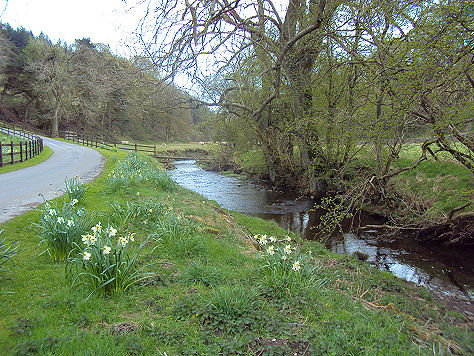
Clough Brook at Wildboarclough
Legend states that it is so named as the last wild boar in England was shot in the hills around Wildboarclough. Some authorities dispute this, stating that the name arose from the rapid rise in levels of the Clough Brook after heavy rain, when a torrent of water or a bore of water floods down the valley and the Clough brook. However, others argue it simply derives from a deep valley (clough) frequented by wild boar.
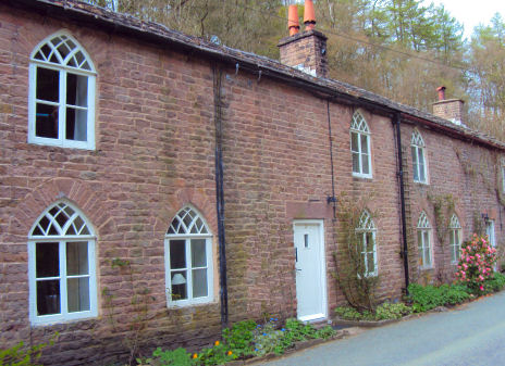
Cottages at Wildboarclough
The peak of Shutlingsloe (506 metres), lies to the north-west of the village. Often referred to as the 'Matterhorn of Cheshire', due to its distinctive triangular profile, Shutlingsloe is the third highest peak in the Cheshire. On a clear day the mountains of North Wales are visible from its summit.
The Old Post Office
The Clough Brook runs through the village, which burst its banks in a flash flood in May, 1989, resulting in the death of a motorist, which is commemorated on a plaque on the stone bridge. Crag Hall which is situated to the east of the village, was built in 1815 by George Palfreyman, the owner of a nearby textile printing works. Mill House and the Old Post Office, which once bore the distinction of being the largest sub-post office in England (pictured left) are the only parts of the mill buildings remaining.
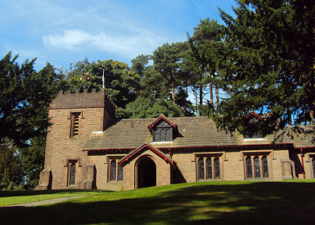
The red sandstone village church of St. Saviour's was built between 1901 and 1909 by Frederick Arthur Stanley, 16th Earl of Derby, to celebrate the safe return of his sons from the Boer War.
St Saviour's Church
Blaze Farm in the village, an admission free attraction, is an award winning farm, famous for its Hilly Billy Ice Cream, in a vast range of unusual flavours, which is made on the farm using the milk from their dairy herd, there are also tea rooms, a farm trail and a paint-a-pot studio for children.
Forest Chapel, otherwise known as the Church of St Stephen high in Macclesfield Forest, is situated in a hollow on the ridge between Langley to the west and the valley of Clough Brook to the east. A chapel has occupied the site since 1673, although the present building dates from 1834. The ancient ceremony of Rushbearing still takes place at Forest Chapel annually on the nearest Sunday to the 12th August, rushes are taken from nearby streams and marshes and laid.
Below Forest Chapel is a pub called the Stanley Arms, which offers a relaxed atmosphere, cask-conditioned real ales and good food, the inn stands on Oven Lane, which crosses Clough Brook here and starts to climb up again to the Cat and Fiddle, the second-highest inn in England.
Nearby places of interest
Three Shires Head, is a beauty spot where the three counties of Derbyshire, Cheshire and Staffordshire meet is a short walk from the Wildboarclough.
Macclesfield Forest, once the centre of a Royal Forest created by the Norman kings for the purpose of hunting game such as deer, wild boar and wolves. It once encompassed all the area from Disley to the River Dane. The forest is home to a herd of red deer, while the reservoirs contain a wide variety of wildfowl.
Shutlingsloe is the third highest peak in the Cheshire (Shining Tor being the highest and Whetstone Ridge the second ) with an elevation of 506 metres (1,660 feet), the summit offers excellent views. On a clear day the mountains of North Wales are visible from its summit.
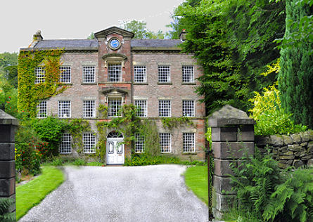
Adlington Hall, set in the heart of the Cheshire countryside, the current building was begun in 1315, although late medieval and Tudor remodeling have since changed its appearance.
A walk from Wildboarclough to Wincle
Distance - 8.5 miles
Duration- Around 3 hours
*Starting from the Wild Boar Inn, cross the field at the back of the pub to reach its far right corner continue to the next field the next field following the wall on your right. Cross 2 further field to arrive at a lane leading to a farm. Turn right at the farm and proceed downhill to arrive at the Wildboarclough to Wincle road, turn left at the road and after a few metres, take the path on the right.
*Cross a stream and continue to reach a T junction. Turn left at the T junction, passing a small coppice,Continue along the path by the stream to reach a car park and road follow road past the Crag Inn and into Wildboarclough. As you enter the village take the road turning on the right and ascend the steep slope to reach Crag Hall.
*From Crag Hall, take the right turn leading to Firs Farm. Pass the farm and continue along the path as it turns sharply right to enter the woods for a few metres, emerging into open fields. Cross the two fields ahead diagonally and continue up to join the Congleton road. Cross the road and take the wide track which heads south east across the moors to join another road. Cross this road and go straight ahead down to the River Dane at Gradbach.
*Cross the footbridge over river and turn right by the Youth Hostel, follow the river downstream towards the wood. Croos a further footbridge and follow the route to Lud's Church. Turn right at Lud's Church to follow a wide track to reach a T junction. Turn right and descend to Hangside Farm. Pass through the farm and across the field behind it to cut through the trees ahead and after crossing a small stream emerge at Danebridge.
*Turn right onto a road and ascend the hill to head to the village of Wincle, cross a river and immediately after passing a pub take the path thatheads off right across the fields to Hog Clough, which you cross before heading diagonally left across another field to again meet a road. Turn right at the road and continue to Hammerton Farm, turn left and continue on passing a group of trees to reach the Congleton road directly opposite the starting point of the Wild Boar Inn.