Three Shires Head
OS Grid ref:- SK009685
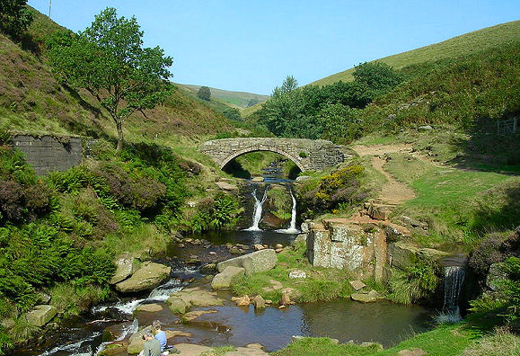
Three Shires Head in the Peak District National Park is a highly picturesque point on Axe Edge Moor where the counties of Cheshire, Derbyshire and Staffordshire meet and is the meeting point of four pack-horse trails.The area is between 360 and 450 metres above sea level. Axe Edge Moor is an upland area of heather, peat-groughs and abandoned coal-mines, with superb views in all directions.
In the eighteenth century, Three Shires Head was a place where criminals and coiners evaded capture from the forces of the law by crossing into a neighbouring county as then it was only possible for police to act within their own county limits.
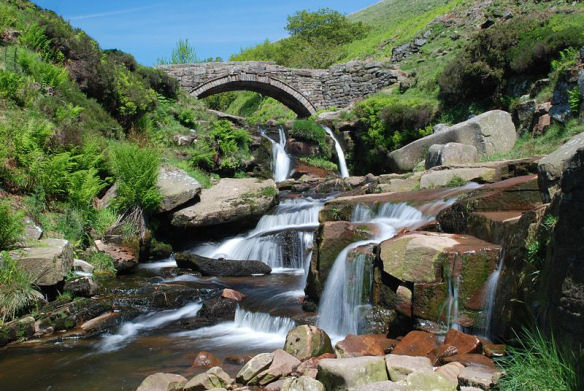
The old stone packhorse bridge and the waterfalls on the River Dane are highly attractive, Panniers Pool, by the bridge is where the packhorse ponies with their heavy panniers or saddlebags would have quenched their thirst. Packhorse trains, strings of up to 40 and even 50 horses, were the principal means of transporting goods from the medieval period up till the seventeenth century. Due to the fact that packhorses could travel over the moors much more easily than wagons, packhorses were still being used in the Peak District well into the nineteenth century.
The beauty spot is not easily accessed, it may be reached on foot from a variety of locations beside either the A53 or A54. The walk of more than a mile crosses over very rough and often boggy terrain.
Image 1 copyright Rob Bendall
A walk to Three Shires Head from the Goyt Valley
Distance -around 7 miles
Duration -around 4 and a half hours
*This walk commences at the car park at the top of the Goyt Valley (SK 018716) just off the A537 road from Buxton to Macclesfield. On exiting the car turn right onto the track that leads to Buxton. Continue along this track until arriving at a rough path to trhe right which heads over the moors. Superb views open up from the summit of the hill.
*Descend the hill and continue along the moor track until reaching a gate and stile on the left. Cross this and proceed along the track until reaching a metalled road, cross the road and and follow the signposted path over the moorland known as Dane Head. Cross a small brook, and follow the path as it ascends steeply uphill. Cross a stile and continue downhill to reach a larger track. Turn to your right and follow the track heading towards the farm in the distance.
*Continue down the track until reaching a gate, go through this and turn left following the lane over a bridge. Continue along the lane keeping the stream on your left descending to Blackhole Clough. Follow the lane to a further gate, go through this and continue until arriving at a small packhorse bridge over a stream, where another packhorse road joins the one that you are following, from the left. Continue down the Clough until you reach the Three Shires Head.
*Retrace your steps to return.
Follow the Country Code
*Be safe- plan ahead and follow any signs.
Protect plants and animals and take your litter home.
Keep dogs under close control
Leave gates and property as you found them