The Forest of Bowland
The Forest of Bowland in Lancashire, a northwestern remnant of the ancient wilderness that once stretched over a large part of England, is designated an Area of Outstanding Natural Beauty.
The area covers 312 square miles of rural Lancashire and North Yorkshire and includes the famous landmark of Pendle Hill. Ward's Stone is the highest fell in the area. The name forest is used in its traditional sense of a royal hunting ground, much of the land in the Forest of Bowland still belongs to the British Crown as part of the Duchy of Lancaster.
Bowland once formed part of the ancient Celtic kingdom of Rheged, but was absorbed into the Anglo-Saxon kingdom of Northumbria in the seventh century.
 The western areas of Bowland became part of Amounderness, a territory founded by the Norse hold Agmundr in the early tenth century. The origins of the name "Bowland" have nothing to do with archery, they derive from the Old Norse boga-/bogi-, meaning a bend in a river.
What to see and where
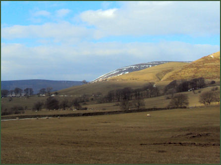
This quiet corner of north Lancashire offers stunning landscapes, picturesque villages and a wealth of historic buildings. The area is dissected by steep sided valleys which open out into the rich green lowlands of the Ribble, Hodder, Wyre and Lune Valleys. On the uplands Bowland is a landscape of heather moorland, peat, acid grassland and blanket bog, with exposed millstone grit outcrops.
The highest point is Ward's Stone which rises to 561 metres. Stocks Reservoir and Gisburn Forest are popular recreational areas within the Forest. The lowlands are characterised by stone built farms and villages; woodland; pastoral scenery and river valleys.
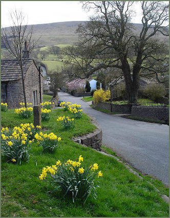
The twenty first century seems hardly to have touched villages such as Slaidburn, Downham and Newton, which have seen very little modern development. The picturesque village of Downham, (pictured left) with its Tudor hall is often quoted as the most beautiful village in Lancashire. Boasting old world charm with warm sandstone buildings and cobbled pavements, Slaidburn has a large, attractive village green, pleasantly situated on on the bank of the River Hodder.
 The picture postcard village of Chipping is a designated conservation area with many characterful stone cottages, a medieval church and a seventeenth century school and almshouses, the village has been the winner of several 'Best Kept Village' competitions, including the village section of the Britain in Bloom competition in 2009.
Bowland Wild Boar Park, near Chipping offers a brilliant and fun day out for all the family and is home to a range of wildlife including Deer, Llamas, Red Squirrels, Goats, Peacocks and Barn Owls. The park has 30 acres of woodland to explore with attractive walks alongside the River Hodder. It also features tractor rides, a play area, lamb Llama and deer feeding. During the summer months visitors can bottle feed the lambs.
Beacon Fell Country Park, situated at Goosnargh, on the edge of the Forest of Bowland, an Area of Outstanding Natural Beauty, is one of the oldest in Britain, being designated in 1970. The Country Park consists of 110 hectares (271 acres) of woodland, moorland and farmland. The summit of Beacon Fell rises to 266 metres (873 feet) and offers stunning views across the plain of the Fylde, with Blackpool Tower and Morecambe Bay to the west, as well as the Ribble valley to the south. On a clear day the Welsh hills, the Lake District hills and the Isle of Man are all visible from the summit.
 Waddington, a delightful village of much character, contains a medieval hall, (below right) which sheltered Henry VI during the
Wars of the Roses and the beautiful Waddington Gardens opposite. The unique village of Ribchester was the site of the Roman fort of Bremetenacum Veteranorum founded by General Agricola, parts of the remains are still visible and Roman Ribchester is brought
to life by dramatic displays in the Roman Museum in the village.
Waddington, a delightful village of much character, contains a medieval hall, (below right) which sheltered Henry VI during the
Wars of the Roses and the beautiful Waddington Gardens opposite. The unique village of Ribchester was the site of the Roman fort of Bremetenacum Veteranorum founded by General Agricola, parts of the remains are still visible and Roman Ribchester is brought
to life by dramatic displays in the Roman Museum in the village.
Newchurch in Pendle lies in the shadow of Pendle Hill and is famous for its associations with the notorious Pendle Witches case. In the early seventeenth century the village was caught up in the largest witch hunt in English legal history. It was a sinister episode that saw the arrest and execution of ten alleged witches. The curious 'eye of God', an elliptic shape on the church tower watches over the village, it was installed some years after the witches’ execution to ward off evil spirits.
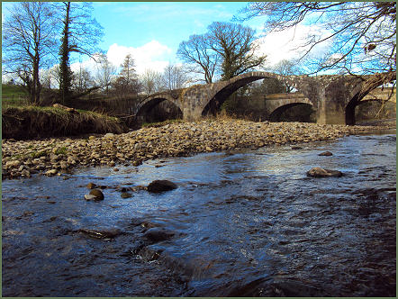
Ancient pack-horse routes and Roman roads are visible reminders of the rich history of this area of Lancashire. Pendle Hill and its associations with witchcraft adds to the mystique of this part of Lancashire.
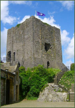
The Norman castle keep at Clitheroe, which stands on a natural limestone outcrop, has dominated the surrounding landscape for over 800 years.
Said to be one of the oldest buildings in Lancashire, and one of the smallest keeps in England, the castle was possibly built by Robert de Lacy circa 1186. The Castle Museum, in the shadow of the Castle Keep, has new look galleries which take the visitor on a journey through 350 million years of history, heritage and geology of the local area
Whalley Abbey, a medieval Cistercian abbey set on the banks of the River Calder, was founded by Henry de Lacy, third Earl of Lincoln on the 4th April 1296. The abbey closed in 1537 as part of the dissolution of the monasteries. Its Abbot Paslew was tried at Lancaster and executed for high treason in Whalley on the 10th March 1537 for taking part the Pilgrimage of Grace, a northern rebellion against King Henry VIII, which had taken place in the previous year.
Only the foundations of the church remain. The remains of the former monastic buildings are more extensive. The west range, which was the lay brothers' dormitory, consists of two stories, and is roofed. To the south of the cloister, part of the walls of the former kitchen and refectory remain. The east range is more complete and includes parts of the walls of the former monks' day room, parlour and vestry. .
The atmospheric ruins nearby Sawley Abbey date back to 1147. Cromwell's Bridge near Hurst Green,(OS Grid Ref- SD 704 391) a picturesque packhorse bridge which dates back to the sixteenth century, was crossed by Oliver Cromwell and his army before before the battle of Preston in 1648.