Derwent Edge
OS grid ref:- SK197909
 The millstone grit escarpment of Derwent Edge is situated above the Upper Derwent Valley and forms part of the National Trust's High Peak Estate.
A highly popular location with walkers and climbers on account of the stunning views it provides over the Upper Derwent Valley and its reservoirs, the Kinder Scout plateau, Edale, Stanage Edge , much of the the area of the Dark Peak and extending beyond, encompassing several counties.
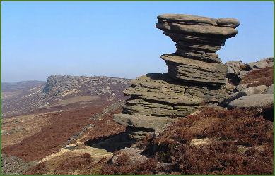
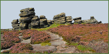
The edge is a remnant of the capping of gritstone that originally covered all of what is now the Peak District, which was scraped off by an ice sheet in the last ice age. It is notable for its oddly shaped gritstone tors, roughly sculpted by the elements over many centuries by the action of wind, rain and frost. These include the quaintly named Cakes of Bread, the Coach and Horses and the Salt Cellar (pictured left). The highest point is at Back Tor (pictured below right) which rises to 538 metres (1,765 feet) and is marked by an Ordinance Survey trig point. To the north of Back Tor the edge extends into Howden Edge.
 The moorland around Derwent Edge has been declared a Site of Special Scientific Interest (SSSI) because of its special vegetation and rare birds and animals, such as the Eurasian Golden Plover, Red Grouse, Ring Ouzel and Mountain Hare. The mountain hare can sometimes be seen, easily distinguished by its white winter coat. Rare species of plants such as Common Cottongrass, Mountain Strawberry, and Crowberry grow in the area. Derwent Edge is rich in archaeology, with evidence of land use and occupation dating back to Neolithic times which include several prehistoric burial mounds.
Derwent Edge may be accessed from a number of locations including the Fairholmes car park in the Upper Derwent Valley (grid ref - SK172893), Cutthroat Bridgeon the A57 (grid ref -SK216873) or from Strines Reservoir car park (grid ref- SK220909) near the Strines public house.