Church Lawton
OS Grid ref:- SJ821557
 The village of Church Lawton, otherwise known as Lawton, is situated near to Congleton and lies on the boundary between Cheshire and Staffordshire. The name derives from the Anglo-Saxon 'Hlaw-tun', meaning the settlement by the mound. The village stands on theTrent Mersey Canal which was completed in 1777.
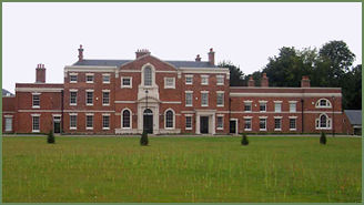
Lawton Hall (pictured left) dates back to the seventeenth century, King Charles II was a visitor to the hall and stood as godfather at the christening of the eldest son of the family. The first house to occupy the site burnt down in the early fifteenth century. This was followed by a more substantial house built by Hugh Lawton and his wife Isabella Madock, which was replaced by the present house in about 1600 by William Lawton and his wife Mary. The interior contains two Jacobean fireplaces and a fine seventeenth century staircase.
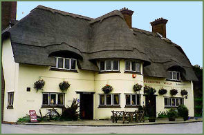 The Hall and surrounding estate has been in the ownership of the Lawton family since its construction. The first record of the Lawton family occurs with Adam de Lauton, who lived in the reign of of King John and Henry III. Local legend states that he rescued Hugh Lupus, Earl of Chester from a ferocious attack by a wounded wolf, when he had become seperated from his companions while hunting in the area and was rewarded by being granted a thousand acres of land which stretched from Congleton to Sandbach by the grateful Earl. The bleeding wolf is still displayed in the arms of the Lawton family, and is also commemorated in the name of a local pub, 'the Bleeding Wolf' (pictured right). A Picturesque building with a thatched roof, the pub serves a range of fine real ales and beers and quality food, freshly prepared using local ingredients.
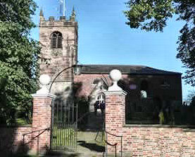 The parish church of All Saints (pictured left) stands on an Iron Age burial mound and dates back to Norman times. It was founded to replace a Saxon church on the site by Hugh Lupus, Earl of Chester, who was granted the Lawton lands by William the Conqueror. A twelfth century semi-circular archway survives on the south entrance. The building was severely damaged by fire in 1798 and the nave was rebuilt in brick in 1803.
Inside the church at the west end is a gallery dated 1717 which survived the fire, at the base of a stairway leading to the gallery is the tomb to John Byber, the rector from 1530 to 1555, it is carved with his initials. During improvement work which was carried out in 1873-74 six thirteenth century tiles were discovered which have been preserved in a carved frame at the back of the church.
On the gallery at the back of the nave is the Royal coat of arms of King George III. Between 1714 and 1837 the Royal coat of arms contained the arms of Hanover in various positions. In the time of George III the Hanoverian arms were on an escutcheon in the centre. Other items of interest include the brass 'Adam and Eve' alms dish which was stolen in 1817 by thieves who may have thought it was gold, and was subsequently thrown into the Trent Mersey Canal from where it was recovered 80 years later. It still bears the marks of the water damage.
The Church Lawton Barrow Cemetery
There is evidence of human activity in the area dating back to the Neolithic era, a polished axe found at Church Lawton was possibly made in Cornwall. The Church Lawton Barrow Cemetery, also known as the Church Lawton Complex, is a significant Bronze Age site. The Complex consists of three Bronze Age mounds of which only two, Church Lawton II and Church Lawton III, survive to the present day. Church Lawton III is the more important and excavations were carried out at the site in the early 1980's.The barrow appears to have been constructed in two phases; the first phase consisted of a stone circle, measuring around 22.5 metres (73 feet 9 inches) in diameter. There were entrances to the north and south of the circle. The second phase covered the central part with soil and surrounded it with a low turf wall.
Church Lawton II was similarly constructed in two phases, firstly, a low mound of sand and gravel subsoil surrounded by a ditch was built. It measured around 16 metres (52 feet) in diameter and 1.5 metres (5 feet) high. In the centre of the mound was a sand-filled boat-shaped hollow with a wooden lid, which was found to be empty of any bones. Eighteen pits, most likely cremation pits, were found on the mound, and four outside the surrounding ditch. In the second phase, the diameter was increased to 30 metres (98 feet), but there were only a number of fire pits and pyres discovered along with one actual cremation. Little is known about Church Lawton I, as it was partially destroyed by the building of the current A5011 road some time before 1881.
Nearby places of interest
Astbury Mere Country Park, owned by the charity Astbury Mere Trust. The park consists of 14ha of open space. Visitors can enjoy panoramic views over Astbury Mere and the surrounding rural landscape. There is a visitor centre, 3km of all weather paths, an easy access trail and excellent footpath links into the local countryside.
Bosley Cloud lies on the Cheshire-Staffordshire border just a couple of miles to the west of the Peak District National Park. It rises to a height of 343 metres (1,125 feet).