Bosley Cloud
OS grid ref:- SJ904636
The gritstone hill known as the Cloud, or Bosley Cloud, near Congleton, lies on the Cheshire-Staffordshire border just a couple of miles to the west of the Peak District National Park. It rises to a height of 343 metres (1,125 feet).
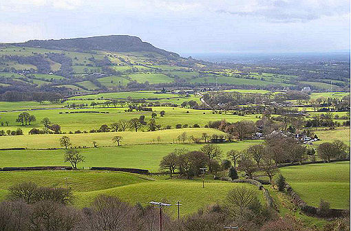
The name is derived from the Old English clud, meaning a rock. Fine views of the Cheshire Plain and the mountains of Wales may be had from the summit of the Cloud. Not far from the trig point and toposcope at the highest point is a possible prehistoric standing stone. The prehistoric Bridestones, a chambered cairn, dating from the Neolithic Age, are located not far away.
A Walk to Bosley Cloud from Congleton
Distance- around 7 miles
*Commencing at the car park situated at the picnic area at Timbersbrook, exit the car park to pass through the picnic area and climb the steps to the road. Turn left, ascending the hill, and continue on to reach an opening on the right, signposted 'Gritstone Trail'.
*On reaching the trig point descend the steep slpoe with care, bearing south-east, where, to arrive on drive to a bungalow, at the lane turn left. Continue on and take the second footpath sign on your right. Cross the stile into a field, then 3 further stiles to arrive at a lane, at which point turn left. On reaching a T-junction, turn right and continue along the road to the stone bridge where it crosses the river.
*Just before reaching the bridge, turn into the wide path on your left, which leads to a bend in the River Dane, turn alongside it, pass through a gate and over a bridge to reach the bridge over the Macclesfield Canal. Cross the bridge and turn left onto the canal towpath. Continue along the towpath, the canal on your left, passing under the railway line and Buxton Road before a large bend turns the direction south, after ging under a second railway for a second time, take the footbridge to cross to the other side of the canal.
* Pass through woodland and keep the edge of the field, to find a track which meets a lane at a metal gate. Cross the and go to the left of farm buildings, pass through a gate and continue to where a green lane, where a stile leads onto the road immediately opposite to the path to The Cloud.
*Turn right on the road to reach a footpath on the right which returns you to the picnic area by the car park.
Follow the Country Code
*Be safe- plan ahead and follow any signs.
Protect plants and animals and take your litter home.
Keep dogs under close control
Leave gates and property as you found them