Wolfscote Dale
OS grid reference :- SK1317 5843
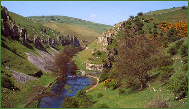
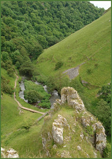 Wolfscote Dale is a spectacular ravine, lying between Beresford Dale and the popular Peak District beauty spot of Dovedale on the border between Staffordshire and Derbyshire.
Legend relates that the last wolf to roam this area of the Peak District was slain by a ford at Wolfscote Dale.
The stunning valley, now in the care of the National Trust, runs northwest to southeast and is deep and steep-sided with a series of weirs along the crystal clear waters of the River Dove. A riverside path runs along the Derbyshire bank of the Dove.
The dramatic scenery is similar to neighbouring Dovedale with a profusion of lofty pinnacles and massive limestone outcrops. The craggy, surrounding rocks offer ideal roosting places for Daubenton’s bats, which are sometimes seen close to water. Small semi alpine wildflowers cling to the crevices in the limestone crags, while herons and dippers are frequently seen flying along the river.
A Neolithic burial cave is located in the outcrop known as Frank 'Ith Rocks, which stands on the eastern side of the River Dove.
The dale passes between between Gratton Hill and Wolfscote Hill. Gratton Hill rises to 1194 feet, Wolfscote is slightly higher, rising to 1272 feet and provides superb views from its boulder strewn summit of the upper and lower Dovedale Valley.
A walk to Wolscote Dale from Hartington
Distance- around 6 miles
 *Park near the duck pond in Hartington and proceed past the Devonshire Arms and Hartington village store, turn right at the newsagents at Hall Bank and follow the road to the left past the youth hostel, continue a little further and just before a barn take the path, Highfield Lane, on the right sign signposted Biggin.
*Continue along this lane until reaching a road. Turn right and take the first track on the right signposted Biggin Dale. Continue through the dale, passing a pond, on reaching a second pond, go through a gate on the left and then turn right following the wall on your right.
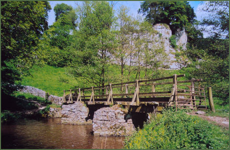
*Continue on until reaching the River Dove. Turn right onto a track entering Wolfscote Dale, follow the path along the River Dove. Go back down to the track and go through the gate next to the bridge, do not go over the bridge, keep the river on your left and go through another gate into a field.
*Cross the field and cross the bridge next to some stepping stones then turn right. With the river is on your right, follow the path for a short distance before crossing another bridge. Follow the path with the river now on your left through woodland to reach open fields.
*Cross two fields to reach a track. Go through a gate over the track and through the gate opposite. Continue along the path to the road then turn right to return to Hartington.