Win Hill
OS Grid ref:- SK186850
 Win Hill is situated at the head of the beautiful Ladybower Reservoir in the Peak District National Park
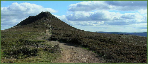
The hill rises to a height of 462 metres (1,516 feet), Win Hill Pike (pictured left), a small conical shaped crag, known locally as 'the pimple' is situated at the summit. Win Hill is connected by a ridge to Kinder Scout.
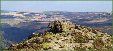
There are many tracks in the area which lead to the hill. The easiest ascent is from the village of Hope, the ascent from Yorkshire Bridge is a very steep climb. The views from the summit over the Ladybower Reservoir, Mam Tor and the hills of the Dark Peak are stunning. A Roman road leads along the ridge and appears to pass over the peak of the Win Hill, while the Hope Cross, a marker post which dates back to 1737, is situated on the slopes of the hill.
Local legend states that Win Hill derives its name from the Dark Age Battle of Win Hill and Lose Hill which is said to have been fought there in 626 AD. The army of Prince Cwichelm and his father, Cynegils, King of Wessex, stationed on nearby Lose Hill and probably aided by Penda, King of Mercia, advanced on the Northumbrians, who were based on Win Hill.
The battle was long and fierce, any by the end the river Noe, which flows between the two hills, is reported to have ran red with blood. Despite having superior numbers, Cynegils forces were defeated by the Northumbrians who built a wall and rolled boulders down upon them. Although there is no record of this battle occuring in any contemporary Anglo-Saxon source, archaeological finds associated with the battle include a large quantity of bones and old weapons which were unearthed near Gore Lane
A walk to the summit of Win Hill
Distance - 8 mies
*Commencing at the Heatherdene pay and display car park on the A6013 at Bamford, exit the car park Go at the far end and follow the track until arriving at steps that descend to the pedestrian crossing to the dam .
 *Cross the dam wall, turn left and continue along the lane which descends the hill. After walking around 300 metres, take the Thornhill Trail which forks off to the right and continue along it until arriving at Carr Lane. Cross the lane and continue along the track on the opposite side of the road. After passing farm buildings a footpath crosses the trail. Take the path on the right hand side and cross a field.
*Cross over Carr Lane again and walk up the driveway of the house opposite to cross a stile positioned part way up the drive. Follow the path as it crosses up and right behind the the rear of the house.
*Continue along the path, passing a farm building, on reaching Townhead Lane turn right and take the lane uphill. On reaching a footpath sign pointing to the left, follow the wall up for about 50 metres until reaching a path. Turn right and continue along the path.
*On arriving at an area of woodland, the path forks about 200 metres from the woods. Take the right fork. Enter the woodland and turn left along the path which ascends steeply to the summit of Win Hill.
*After taking in the stunning views across the Dark Peak, continue West along the ridge of the hill falong the main path. After walking just over a mile the path passes through a dry stone wall. Turn right and continue to the metal gate into woodland. Continue along this path as it veers to the left, then leaves the woods and turns sharp right dto descend the hill.
*Cross the track and continue downhill, crossing a second track and entering woodland to arrive at the track around a reservoir. Turn right on reach the main path along the bank of the reservoir. Continue along this path until reaching the dam wall. Cross the dam wall and retrace your steps back to the car park.