Wetton
OS Grid ref:- SK109555
 The small village of Wetton, once an estate village of the Dukes of Devonshire, is situated at the top of the east side of the Manifold Valley in the White Peak area of the Peak District National Park. With its position close to Thor's Cave and the other attractions of the Manifold Valley, Wetton is a popular tourist location.
The village is centred around its green and has an inn, Ye Olde Royal Oak, which dates back to at least 1760 and is famous for its annual toe wrestling competition, first held in 1993. The inn serves home cooked food and a selection of fine real ales.
The characterful village l Church of St Margaret has an unusual external staircase to its belfry. Part of the building dates back to the fourteenth century. In the churchyard yard is the grave of Samuel Carrington. Carrington was the village schoolmaster, but is more famous as an archaeologist. Together with Thomas Bateman of Middleton-by-Youlgreave, he excavated sizeable Romano-British settlements at Borough Fields and Long Low.
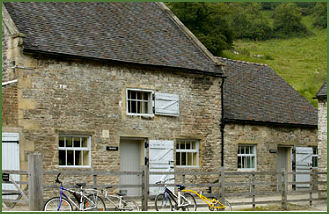 Wetton Mill (pictured right) was once used for for grinding corn, and the remains of a mill stream, along with a grindstone, may still be viewed today. The mill is long since disused, but the Tea Room remains popular with tourists. The mill was established in the valley by William Cavendish, the second son of the formidable Bess of Hardwick and is now owned by the National Trust.
The area to the east of the village is marked out with long narrow fields, whose origin probably dates back to medieval strips.
About 2 kilometres to the south east of the village stands the Long Low Neolithic and Bronze Age site (OS grid reference SK122539) The site consists of two round cairns linked by a connecting bank. The northern cairn measures 23 metres in diameter and survives to a height of 2.4 metres. It was excavated by Samuel Carrington in 1849 when the bones of thirteen people and three leaf-shaped flint arrowheads were discovered. The smaller southern cairn measures 15 metres across and survives to 1.2 metres in height. It contained evidence of a cremation burial.
Nearby places of interest
The Manifold Valley, which runs almost parallel with Dovedale, has been described as the 'Switzerland of Staffordshire' and offers some of the most spectacular scenery in the Peak District National Park.
Ilam Park Beautiful Ilam Country Park is situated at the Peak District village of Ilam to the north west of Ashbourne. The park covers 158 acres (0.64 km2) on both sides of the River Manifold.
Dovedale, a dramatic limestone ravine, with its mpressive rock outcrops and tranquil woodlands is arguably the prettiest of the dales in the Peak District National Park and is owned by the National Trust.
Biddulph Grange, one of Britain's most exciting and unusual gardens, was created by the horticulturalist James Bateman (18111897), for his large collection of plants from around the world.
Haddon Hall near Bakewell, is an architectural gem. Dating back to the eleventh century, the hall has been described as "the most complete and most interesting house of [its] period", it is the finest example of a medieval manor house currently in existence in England.