Thurstaston Common
Thurstaston Common and Royden Park consist of a large area of heath and woodland on the Wirral Peninsula.
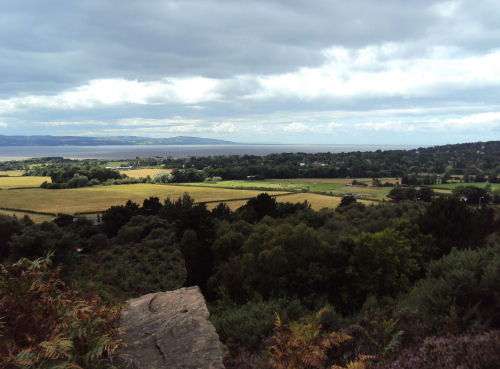
The Dee Estuary from Thurstaston Common
The site is jointly owned by Wirral Borough Council and The National Trust the site is managed by Wirral Rangers. Habitat varies from mixed woodland dominated by birches, oak, sycamore and rowan to wet and dry heath. Locally rare plants such as marsh gentian, oblong-leaved sundew and round-leaved sundew are found on the common. Animals include common lizard and birds such as yellowhammer and meadow pipit feed and nest in the heather.
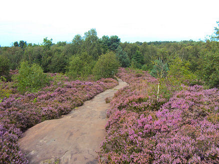
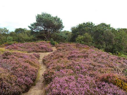
The Common ablaze with heather in late summer
Thurstaston is a popular spot with walkers for the superb views, at just 90m above sea level, it offers some of the best the Wirral has to offer, from the summit of Thurstaston Hill the views encompass the Liverpool skyline, the Welsh hills over the River Dee, the Irish Sea coast and, in clear weather, Snowdonia, the Pennine Hills, the Lake District. A viewfinder erected in memory of Andrew Blair, founder of Liverpool and District Ramblers Association, helps visitors find their bearings. The Common is a designated Site of Special Scientific Interest and is home to a variety of wildlife including dragonflies, common lizards, tawny owl, jay and sparrowhawk, woodpeckers can also be sighted in the pine plantations.
Thor's Stone
Thor's Stone, a large red sandstone outcrop on the common of unusual shape and appearance, is a place shrouded in legend. Early Viking settlers are purported to have held religious ceremonies there. A large rectangular block of stone that is 50 feet in length, 30 feet wide by 25 foot high which has been eroded over thousands of years.
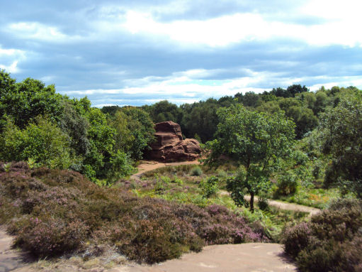
Local folklore tells that the rock is named after the Norse thunder god Thor. Viking settlers from Thingwall apparently settled here in the 10th century and according to legend, they used the stone as a pagan altar. The stone was also known locally as 'Fair Maiden's Hall', the curious rock was moulded by water flows under the ice at the end of the last Ice Age and further modified by subsequent erosion and possible quarrying. The small pool to the left of Thor's Stone is one of the wetland areas to be found on the heath.
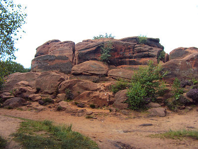
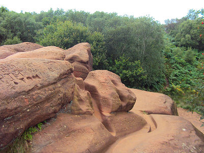
The top of Thor's Stone can be reached by a choice of easy scrambles up the heavily eroded rock. The outlines of 230 million year old sand dunes can be detected in the rock layers, a reminder that the area was an equatorial desert in the Triassic period.
A walk at Thurstaston Common
Distance- 5 miles (8.4km)
Duration - around 2 hours
*Commencing from the Wirral Country Park car park at bottom of Station Road in Thurstaston, pass the visitor centre and wildlife pond and exit onto Station Road. Proceed for around ½ mile then turn left before the church and onto the A540. Go left, past the Cottage Loaf, then go right through a kissing gate.
*Follow the track straight ahead to the end of a cul-de-sac, pass through a kissing gate to a path then go right on a smaller path. Cross a track near a cattle grid and take the left of two available tracks. This swings left and crosses a clearing. Go right to meet a clearer path just inside the edge of the wood. Go left, following the course of the brook. Turn left alongside the wall and keep straight on when it ends.
*Alongside Royden Park the wall resumes. Where it ends again turn left by a sign and map. Cross a clearing to a junction 5. Twenty yards (18m) further on is a kissing gate. Turn right before it, on a narrow path. Cross another path and make your way through gorse for 20yds (18m) to a broader path.
*Go left then up past a marker stone, go down the steps, pass a small pool, then climb to a larger area of bare rock. Go right here and when the path forks, go left, then right, through trees. Go left on a broad path to a sandstone pillar with a map/view indicator and then the trig point.
*Descend a broad path that rejoins the outward route. Retrace your steps past the Cottage Loaf and down the top section of Station Road. Turn left past the church. When the road swings round to the left, a lane continues straight ahead. Cross a stile and follow a well-marked footpath. In a dip cross a stream and turn right at a footpath sign. After recrossing the stream, zig-zag down a steeper slope into The Dungeon.
* Cross the stream again and follow it down. Climb on to an old railway embankment and go right. When green gates bar the way, sidestep left. Continue for another 220yds to a gap in the hedge. Follow a path, winding past a couple of ponds then out to the cliff tops above the estuary. Go right for 240yds then bear right across grass to return to the the car park.
Follow the Country Code
*Be safe- plan ahead and follow any signs.
Protect plants and animals and take your litter home.
Keep dogs under close control
Leave gates and property as you found them