Stanton Moor
OS grid ref:- SK249634
 Stanton Moor consists of a plateau which rises to 280-320 metres above sea level and lies between Matlock and Bakewell in the White Peak. There are superb views over the Derwent Valley from the moor. In late summer the moor is covered with a colourful carpet of heather and buzzards falcons and sparrowhawks are frequently sighted. The northern end of the moor is clothed in silver birch woods.
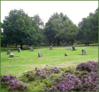
Famed for its many prehistoric sites, the wild upland area was an important site in the Bronze Age. There are four stone circles, dating from the Bronze Age and at least 70 barrows on the moor. The most famous of these is the Nine Ladies Stone Circle. (pictured left)
The small stone circle consists of nine millstone grit stones, each of which measures less than a metre high. The stones form a rough circle with a diameter of about 10 metres, the circle has a gap at the south side. An additional stone, which now lies flat , was discovered after being exposed as a crop mark in the dry summer of 1976.
The circle, which is owned by English Heritage, stands on a stone rubble embankment. The small graffiti covered 'King Stone' lies around forty metres from the circle and once formed part of a now destroyed ring cairn.
 To the north of Nine Ladies lies a circle identified as 'Stanton Moor I' (OS grid ref- SK 249637) Excavations revealed a large number of collared urns, cremations, two minature cups, a cordoned urn and a bronze awl. To its south lie Stanton Moor III and Stanton Moor IV.
Doll Tor lies a just west of the moor by a small wood,it consists of six standing stones with an adjoining cairn to the eastern side of the circle. The diameter of the circle measures around 6m by 4.5 metres.
The moor has long been considered as a sacred place for the ancient Celtic priests, the Druids, and many of the `menhirs' or monoliths are believed to have sacred significance and to be associated with Druid worship.
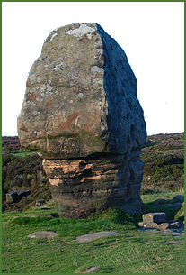
The large gritstones on the moor are natural features where harder stone outcrops were left as the plateau wore down.The Cork Stone (pictured right), one of of a number of impressive natural outcrops on Stanton Moor. Composed of weathered sandstone it resembles a massive mushroom or cork. The stone is covered in graffiti from the nineteenth and twentieth centuries and has steps carved into the side to allow access to the top. The Andle Stone, a huge natural boulder which may have been significant in neolithic times has ancient rock carvings on the top, victorian tributes to military leaders on the back and footholes carved in the face to allow easier access to the views from the top
The Earl Grey Tower, otherwise known as the Reform Tower, a square stone building which rises to a height of 35 feet, it is situated on the eastern edge of the moor and was built by William Pole Thornhill and commemorates the Reform Act of 1832. There are several old dormant quarries around the moor. Recent attempts to re-open dormant quarries failed after much local and national protest.