The Roaches
OS Grid ref:- SK001638
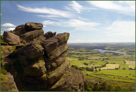 The Roaches is a prominent gritstone ridge situated above Leek and Tittesworth Reservoir in the Peak District. An iconic Peak District National Park landscape, offering stunning panoramic views, the name derives from the Norman French les roches - the rocks. The Roaches are the most prominent part of a curving ridge which extends for several miles from Hen Cloud in the south to Back Forest and Hangingstone in the northwest. Nearby are the broad hills of Gun and Morridge.
The steep ridge rises to 505 m (1,657 ft). Along with Ramshaw Rocks and Hen Cloud the Roaches form a gritstone escarpment, which is very popular place with hikers and rock climbers and is often very busy especially at weekends. The curious Winking Man rock formation overlooks the Leek to Buxton road, it resembles a mans face due to the fact that it looks like a mans head with a forehead, nose, mouth and chin.
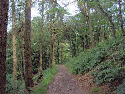
 Nearby Lud's Church is an immense natural cleft in the rock on the hillside near the small hamlet of Gradbach, in a forest area known as the Black Forest. The feature has been formed by a landslip which has detached a large section of rock from the hillside, thus forming a cleft which is over 15 metres high in places and over 100 metres long. Dripping grasses, mosses and ferns cling to the vertical sides of the atmospheric chasm, it remains cool even on warm days and is wreathed in myth and legend.
The Roaches once belonged to the Swythamley Estate. Following the break up of this estate, it was purchased by the Peak District National Park Authority in the 1980s to safeguard the area from adverse development. In clear conditions, it is possible to see much of Cheshire and views stretching as far as Snowdon in Wales and Winter Hill in Lancashire.
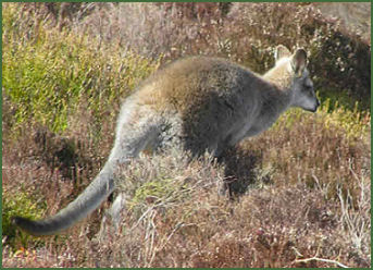
In the 1930s five Australian Bennett's wallabies (or red-necked Tasmanian wallabies) were released into the wild from the private zoo of Captain Courtney Brocklehurst of Swythamley at the start of the Second World War, surprisingly they survived and bred there. A colony of their descendants inhabited the area for many decades until the late 1990s. The colony was hard hit by the harsh winter of 1962-63 but their numbers were back into the high teens by the 1970s and 1980s.. By 2000 they were feared to have died out completely. However, a few are believed to have survived to the present day.
A walk from the Roaches to Lud's Church
Distance:- about 7 miles
*Commencing at the road near Hen Cloud, walk north along the lane to turn right at the first major path you encounter. Continue along this path to reach to Well Farm. Leaving the main path over the col walk in front and then to the left of the small stone built house called "Rockhall".
*Follow the path that ascends through the crags to the ridge and follow along the ridge north. Turn off right from the main ridge path downhill section to Roach End and go north crossing the first stile in the wall on the left. This leads on to a track which descends towards Gradbach Wood.
*On entering the wood the path follow along the track signposted for Lud's Church.
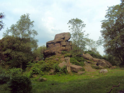
*Pass some curious rock formations on the right, continue to follow the signposted track to to arrive at the ravine.
*After looking around Lud's Church, join the main path coming up from Gradbach heading west towards Danebridge. Turn left on arriving at at the Western end of the Roaches, pass above High Forest Farm before finally dropping down to Roach End. Continue along the road to return to where you parked.
Follow the Country Code
*Be safe- plan ahead and follow any signs.
Protect plants and animals and take your litter home.
Keep dogs under close control
Leave gates and property as you found them