Marple Bridge
OS Grid ref:- SJ971893
The village of Marple Bridge is situated close to the town of Marple in an attractive location on the western edge of the Peak District. The name Marple is thought to derive from one of two old English sources, meaning either boundary on the hill or boundary by the river.
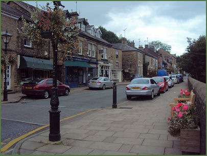
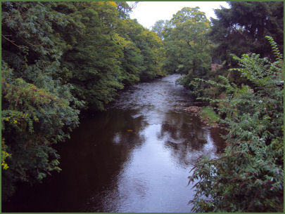
The tree lined valley of the River Goyt runs through the village. The attractive village centre, consisting mainly of stone buildings, is a conservation area. The centre has coffee shops, traditional and trendy pubs and other individual shops.
Brabyn's Park was once the estate attached to Brabyns Hall. It covers 90 acres (37 hectares) of parkland, woodland, riverside walks and playing fields, and was first opened to the public in 1947. The Roman Lakes Leisure Park once supplied water to the long-disappeared Samuel Oldknow's Mellor Mill cotton mill and is now the venue for a variety of recreational and sporting activities. The park contains a history and a nature trail and is highly popular with walkers, anglers and horse riders. It is situated in the valley bottom close to Strines. The picturesque Roman Bridge which spans the river is an old packhorse bridge dating back to the 1700's.
One of the North-Wests biggest outdoor Christmas events, Marple Bridge Winter Wonderland is a community organised street fair and party that takes place in the main street of the village, which is closed to traffic for the afternoon. Winter Wonderland usually takes place on the first Saturday in December.
Nearby places of interest
Kinder Scout, a moorland plateau, rising to 636 metres (2,087 ft) which is highest point in the Peak District.
Lyme Park is situated in a spectacular moorland setting at Disley near Stockport on the edge of the Peak District National Park. The house and surrounding estate are owned by the National Trust. The lavishly decorated Italianate house has spectacular seventeen acre gardens, which include the Victorian Garden and Edwardian rose garden.
Mellor Iron Age Fort Iron Age settlement discovered in the 1990's, occupied from the Bronze Age to the Romano-British period, featuring a reconstructed Iron Age roundhouse.
Dunge Valley Gardens are situated just to the west of Windgather Rocks and are well worth a visit, especially in April and May when the rhododendron's are in bloom.