Hayfield
OS Grid ref:- SK036869
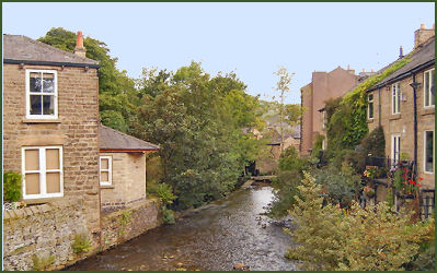 The picturesque Derbyshire Peak District village of Hayfield nestles at the foot of the moorland plateau of Kinder Scout, a former mill village in the valley of the River Sett, it is situated near to the border with Cheshire.
An ancient settlement, Hayfield is mentioned in the Domesday Book where it is referred to as 'Hedfeld' and was then a clearing in the vast forest that once covered the whole of this area of the Peak District.
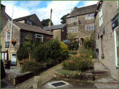
The village was once a staging post on the pack-horse route across the Pennines from Cheshire to Yorkshire. The old centre of Hayfield is highly attractive and boasts a handsome church, St Matthews, and a host of characterful cottages, shops and cafes.
The actor Arthur Lowe, perhaps most famous for his role as Captain George Mainwaring in the television show Dad's Army, was born and grew up in the village.
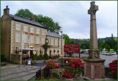 There are a number of pubs in the village including the charcterful stone builtPack Horse Inn and the Royal Hotel which overlooks the river. The village has a cricket field where Hayfield Cricket Club play. The ground is located next to the Royal Hotel, and was purchased by the club in 1976 after famous ex-resident Arthur Lowe helped raise the necessary £5,000.
Panoramic Kinder Reservoir lies to the north east of the village and is around a 2 mile walk from Bowden Bridge Quarry car park, which is situated near the camp site. The reservoir controls the flow of the River Sett, thereby avoiding the risk of flooding that had previously been a serious problem in the village. At least 2 previous bridges on the river, occupying the site of the present bridge (which dates to 1837), where swept away by the force of the river.
 Hayfield is the traditional starting point for the ascent of Kinder Scout, a bleak and rugged moorland plateau, rising to 636 metres (2,087 ft) which is highest point in the Peak District. Views from the summit on a clear day include the city of Manchester and the Greater Manchester conurbation can be seen, as well as Winter Hill near Bolton, and the mountains of Snowdonia in North Wales.
Kinder Downfall is the highest waterfall in the Peak District National Park, with a 30 metre drop. The waterfall is situated on the River Kinder, where it flows down the end wall of the natural amphitheatre of Kinder Scout. The village is the home of the Kinder Mountain Rescue Team.
Bowden Bridge quarry a mile to the north west of the village, was the starting point for the Mass Trespass on Kinder Scout in April 1932 which Roy Hattersley has described as "the most successful direct action in British history", seen as a working class struggle for the right of walkers to roam versus the rights of the wealthy to have exclusive use of moorlands for grouse shooting.
The mass trespass marked the beginning of a media campaign by The Ramblers Association, culminating in the Countryside and Rights of Way Act 2000, which legislates rights to walk on mapped access land. A commemorative plaque at the quarry marks the start of the trespass. It was unveiled in April 1982 by an aged Benny Rothman, famous for his leading role in the mass trespass during a rally to mark the 50th anniversary.
Hayfield Countryside Centre is situated at the eastern end of the Sett Valley Trail, a 2½ mile traffic free route for walkers, horse riders and cyclists created on a former railway line. A short 500 metre walk from the countryside centre, along the Sett Valley Trail, is the beautiful Bluebell Wood Local Nature Reserve.
St. Matthew's Church and the River Sett at Hayfield
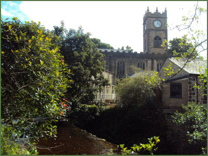
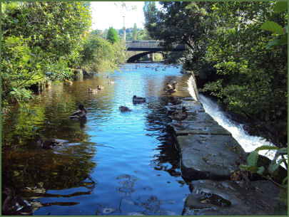
The village church of St. Matthew was founded in the fourteenth century but was largely rebuilt in 181718. Some remains of the earlier building are still visible in the crypt.
Well Dressing at Hayfield
 There are several natural springs located at Hayfield, some of which once supplied part of the village's water supply. These are no longer in active use, although are 'dressed' annually in well dressing ceremonies.
The wells are located at Bank Street (main well), Little Hayfield, Valley Road, St Johns Methodist Church, New Mills Road Cenotaph and Swallow House Lane. All the wells are signposted from the centre of the village.
The origins of this exclusively Derbyshire custom are lost in the mists of time. It is thought to have developed from the old pagan custom of making sacrifice to the gods of wells and springs to ensure a continued supply of fresh water. The fact that many well dressings have a 'well queen' does suggests echoes of ancient spring fertility rites. However, some sources state the practice began after the Black Death of 1348-9, a great plague which claimed the lives of a third of the population of England. Some villages such as Tissington in Derbyshire, were left untouched by the disease. The inhabitants attributed this to their clean water supply and gave thanks by 'dressing' the village wells.
The custom of well dressing had almost died out by the early years of the twentieth century, but was resumed in the 1920s and 1930s. The custom has since been revived, primarily for the tourist industry, in numerous villages and small towns in Derbyshire, Cheshire, Staffordshire and South Yorkshire.
The construction of the well dressings is an art requiring skill. Wet clay is spread a few inches thick across a wooden backing board, a design is 'pricked out' in the clay using a paper pattern and then petals and other items are positioned to form the design. After the 'dressing' the well it is blessed.
Nearby places of interest
Kinder Scout, a moorland plateau, rising to 636 metres (2,087 ft) which is highest point in the Peak District.
Lyme Park is situated in a spectacular moorland setting at Disley near Stockport on the edge of the Peak District National Park. The house and surrounding estate are owned by the National Trust. The lavishly decorated Italianate house has spectacular seventeen acre gardens, which include the Victorian Garden and Edwardian rose garden.
Mellor Iron Age Fort Iron Age settlement discovered in the 1990's, occupied from the Bronze Age to the Romano-British period, featuring a reconstructed Iron Age roundhouse.
Dunge Valley Gardens are situated just to the west of Windgather Rocks and are well worth a visit, especially in April and May when the rhododendron's are in bloom.